How is the jet stream connected to simultaneous heatwaves across the globe?
The deadly heatwaves that have fuelled blazes and caused transport disruptions in Europe, the US and China this month have one thing in common: a peculiar shape in the jet stream dubbed “wavenumber 5”.
Scientists are racing to understand whether the band of fast-moving air that controls weather in the mid-latitudes is changing in a way that makes heatwaves more frequent and persistent.
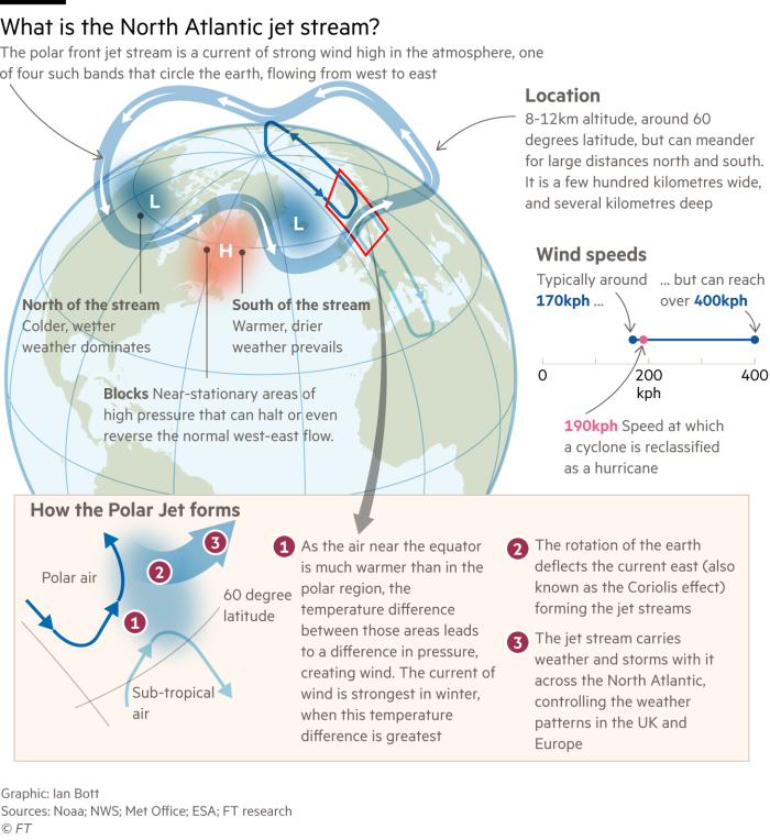
“The jet stream is the leading driver of our weather,” explains Paul Williams, professor of atmospheric science at the University of Reading. “The jet stream is like a conveyor belt, delivering storms to us one after the other.”

It can also generate heatwaves when it forms into a U-bend shape, called an “omega block” because it resembles the shape of the Greek letter omega.
Right now, a global pattern of five big waves is circling the world, leading to simultaneous heatwaves across continents. This pattern, known as wavenumber 5, can persist for weeks, causing hot areas to stay hot for a long time.
In China, more than 900m people are experiencing heatwaves, and more than 70 weather stations have broken records this month. In the US, Texas and Oklahoma are experiencing record-high daily temperatures, and more than 20 states have issued heat warnings.
The UK also recorded its highest-ever temperature this week — 40.3C — while France and Spain have been battling wildfires after an extreme heatwave that has lasted for weeks and set temperature records.
“As often happens in the atmosphere, it is connected: if we see an extreme event in one place, it can be connected to extreme events in another,” says Stephen Belcher, chief scientist at the UK Met Office. “The Met Office forecasters are looking very, very closely at this wavenumber 5 pattern to see how long it persists,” he added.

Belcher says three factors contributed to the heatwave over Europe: the wavenumber 5 pattern in the jet stream; the increase in global average temperatures; and the dry soils, particularly around the Mediterranean, resulting from prolonged hot weather.
Dim Coumou, a climate scientist at VU Amsterdam, says there are two important patterns in the jet stream in summer — with five waves, or with seven waves — that tend to remain in the same place when they form. “If such wave patterns become stagnant and persist over longer periods, then we typically see simultaneous heatwaves.”
A growing body of research is trying to answer the question of how exactly the jet stream is being changed by global warming and what this means for future weather patterns. Temperatures have already risen by about 1.1C since pre-industrial times due to human activity.
The jet stream itself appears to be changing its behaviour over the long term and slowing down in summer — which can make the “omega block” pattern more likely.
Jennifer Francis, an atmospheric scientist at Woodwell Climate Research Center, says the rapid warming of the Arctic region appears to be the cause of this slowdown.
“There is a general decrease in the winds in summer,” says Francis. “The reason there is a jet stream at all, is because it is cold to the north, and warm to the south, and that temperature difference creates [the condition for the jet stream],” she said.

Because the Arctic is warming much faster than the rest of the planet, there is less temperature difference between those air masses now.
Some of the jet stream behaviour is still unexplained: “Over the Atlantic, the jet has shifted south in summer,” says Tim Woollings, author of Jet Stream and professor of atmospheric physics at Oxford. “Whereas we were expecting it to shift north in response to climate change.”
The heatwave that the UK recently experienced is “just a little taster” of what the rest of Europe experienced, says Woollings. “The real event is over Spain and France,” he says.
The UK experienced two days of extremely high temperatures on Monday and Tuesday before the weather cooled off; Spain and France have seen elevated temperatures for weeks.
As global average temperatures increase, climate models show that heatwaves will get hotter. However, it could be years before researchers know precisely how global warming is influencing these patterns of the jet stream.
“We need a very long record of observation,” says Williams. “It might be decades, or even a century, before we convincingly detect any changes.”
Climate Capital

Where climate change meets business, markets and politics. Explore the FT’s coverage here.
Are you curious about the FT’s environmental sustainability commitments? Find out more about our science-based targets here